Burn Day Status
April 19
-
Coastal
-
Inland
April 19
Coastal
Inland
San Luis Obispo County skies are typically clear and blue with little of the characteristic brown haze associated with areas considered to have poor air quality, yet we still have an air pollution problem. Violations of the state standard for particulate matter (PM10) still occur several times a year. In order to understand why we need to work to improve our air, we need to understand how air quality is determined.
Based upon the potential for health and economic effects, certain substances have been classified as pollutants by the federal and state governments. Air monitoring is required to measure the amounts of these pollutants that are present in our air. When the levels are too high, our air is classified as polluted, and we are required to make efforts to clean it up.
In years past, air quality in our county has exceeded established standards for lead, carbon monoxide, sulfur dioxide, ozone, and particulate matter. Advancements in emission controls on vehicles and stationary pollution sources of all kinds have led to significant improvements in our air quality. As a result, we now meet most of these standards. With even better emission controls, and with continued help from businesses and the public, we should be able to achieve all state and federal air quality standards in the near future.
Want to learn more about the air quality in our area? View the current Air Quality Index for your location by visiting the Air Now webpage. San Luis Obispo County cities are located near the bottom of the California listing; scroll to find the location and AQI closest to you.
The Air Quality Forecast is available for eight San Luis Obispo County regions. Sign up here to have the air quality forecast emailed to you daily.
Need more information on what the Air Quality Index (AQI) is and what their associated colors mean? Find out here!
On April 28, 2005, the California Air Resources Board (ARB) approved the nation's most health protective ozone standard with special consideration for children's health. Based on monitoring data, San Luis Obispo County has been designated nonattainment for the new ozone standard.
The Air Resources Board maintains a website with designation maps of California for all criteria pollutants that are designated for the State and National standards. These maps show attainment status for all air districts in California and are updated annually for the State Area Designations, as required by the Health and Safety Code (H&SC) section 39608. The Board makes State Area Designations for ten criteria pollutants: ozone, suspended particulate matter (PM10), fine suspended particulate matter (PM2.5), carbon monoxide, nitrogen dioxide, sulfur dioxide, sulfates, lead, hydrogen sulfide, and visibility reducing particles.
This table lists the air quality attainment status for criteria pollutants in San Luis Obispo County.
Exceptional events, like wildfires, can affect the county's air quality designation. To demonstrate that the wildfire impacts meet the criteria for an exception event and do not affect the county’s attainment status, documentation must be submitted to USEPA.
The 2008 wildfires produced ozone precursor emissions which significantly impacted ambient ozone measurements in San Luis Obispo County. Three documents were submitted by the San Luis Obispo County Air Pollution Control District to the California Air Resources Board to demonstrate that the wildfire impacts meet the criteria for an exceptional event, as defined by federal policies.
The March 10, 2009 report presents additional analyses to demonstrate the exceptional nature of the wildfires impact on ozone measurements in San Luis Obispo County. Additional data regarding the exceptional event was provided on June 2, 2009.
The August 14, 2009 report presents analyses to demonstrate the exceptional nature of the Lockheed wildfire impact on PM 2.5 measurements in Atascadero.
Nine air monitoring stations are located at different sites around our county. At these monitoring stations, we collect information 24 hours per day, seven days per week, on the ambient levels of pollutants, including ozone (O3), particulate matter (PM10), nitrogen oxides (NOx), sulfur oxides (SOx), and carbon monoxide (CO). To find out which pollutants are monitored at each monitoring site location, look at our listing of monitoring stations. The levels of each of these pollutants are compared to the state and federal standards in order to determine whether or not we are in compliance. The District reports all monitoring data to a comprehensive national database maintained by the United States Environmental Protection Agency (USEPA). The California Air Resources Board (CARB) then draws all California monitoring data from USEPA for state uses.
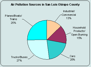
We have many different sources of air pollution in our county. Sources range from large power plants to small household painting projects. By far the largest contributor of air pollution in our county is motor vehicles. The pie chart below shows emission sources of reactive organic gases (ROG) and oxides of nitrogen (NOx), the main precursors for ozone formation.
Although many of the substances classified as pollutants do occur naturally at low concentrations, much higher and unhealthful levels can be created by human activity.
Ozone, for example, is a natural component of our air. Hydrocarbons and nitrogen oxides released from vehicles and industrial sources, however, can react in the presence of sunlight, forming much higher levels of ozone than forms naturally. These higher levels of ozone can result in health effects, such as impaired breathing and lung damage, or economic effects, such as damage to crops and accelerated deterioration of rubber, plastics and many common building materials.
Particulate Matter (PM10) and Fine Particulate Matter (PM2.5) are fine mineral, metal, smoke, soot, and dust particles suspended in the air. While particulate matter also has many natural sources, human derived sources such as vehicle exhaust, road dust, mineral quarries, grading, demolition, agricultural tilling, and burning are major contributors to exceedances in our county. In addition to reducing visibility, particulate matter can lodge in the lungs and cause serious, long-term respiratory illness and other health problems. The smaller the size of the particle, the deeper it can penetrate into the lungs, and the more difficult it is to expel.
Air quality standards are established to protect even the most sensitive individuals in our communities. These standards indicate the maximum amount of a pollutant that can be present in outdoor air without harm to the public's health. Both the California Air Resources Board (ARB) and the U.S. Environmental Protection Agency (USEPA) are authorized to set ambient air quality standards.
For information on the current air quality standards and area designation visit the California Air Resources Board Air Quality Standards Site.
The District has compiled weekly or annual summaries and multiple year trend analyses of air pollution monitoring in our county. More 
Air monitoring stations collect data throughout the county. Some of the stations are larger than others and monitor for a wider number of pollutants. More
Multiple stationary, area and mobile sources release air emissions in our county. The District compiles an emission inventory of these sources on an annual basis. More
Each year, the District reflects on the air quality in our county. Our annual report contains information on air quality monitoring, and pollutant trends. More
Each year, the District prepares an Network Assessment. The Network Assessment is a more detailed examination and assessment of the technical aspects of the monitoring program performed every five years. More
Many air pollutants are a concern because they can result in health impacts to living systems. Respiratory problems, such as asthma, can often be aggravated due to exposures of high concentrations of pollutants. More